Politics & Government
By Boat, EPA Collects Water Samples for Monitoring Barnegat Bay
The EPA will continue its numerous testing of the Barnegat Bay as part of Gov. Chris Christie's 10-point Action Plan


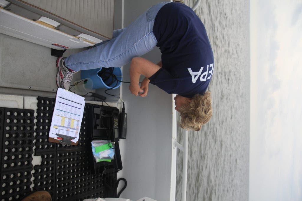


At 8 a.m. several days a month, staff of the Environmental Protection Agency sets out for the Barnegat Bay by boat. Leaving from Southwinds Marina in Forked River, the group sets sail on this overcast morning to pull water samples as part of Gov. Chris Christie's 10-point plan to clean up the bay.
“We are a part of the larger effect that is led by NJDEP,” Braun said. “The bay is being impacted by development on shore. There is a lot of runoff flowing into the Bay from fertilizer and other chemicals.”
Three groups were sent to take samples of the water in the Barnegat Bay on Monday morning. The groups had 13 spots to pull samples from, and all had to be collected between 8 and 10 a.m. so they could see how the entire Bay looked during that time. Samples are tested from the waters surface, as well as along the bottom of the bay.
Find out what's happening in Toms Riverwith free, real-time updates from Patch.
The samples are ultimately used to address the ecological decline of the bay, said Randy Braun, chief of EPA Region 2's monitoring operation section.
The EPA tests the water once a month during the winter months and as often as every week in the summer. Twice during the summer, the EPA will test the water for 16 hrs a day, four days a week. According to Darvene Adams, an environmental scientist for the EPA, the water is tested for a list of items.
Find out what's happening in Toms Riverwith free, real-time updates from Patch.
“The samples we take on the water are stored and will be processed at a lab to check for nutrients, turbidity and several other factors,” Adams said. “Here on the water we check the clarity, the pH and the temperature of the water. We also watch the oxygen levels in the water. They usually drop in the summer months, which is a cause for concern.”
The EPA tested the Bay in four locations, one off the Toms River, one off Island Beach State Park, one off Oyster Creek and one off the Barnegat Lighthouse. The average temperature of the water being tested at the surface was roughly 82 degrees Fahrenheit.
“The whole idea of this sampling is to get an idea of the health of the Bay,” Braun said. “The results can tell us what’s happening in the Bay and help predict the future of the Bay.”
Along with sending out teams for samples, the NJDEP has deployed several yellow buoys in the water that keep a constant monitor of the water.
From the figures, the EPA can compare and contrast the findings from each location across the same dates or a long period of time. For example, the pH, which measures the acidity (low pH) or alkalinity (high pH) of the water, of the North Branch Forked River site on March 22 was 4.77 while it was 4.36 on March 6. The pH of the South Branch Forked River site was 4.38 on March 22 and 4.41 on March 6. A pH of 7 is considered neutral.
The EPA also has reports that found the Middle Branch Forked River site had a fair index impairment and an optimal habitat rating for macroinvertebrates while the Oyster Creek site was also optimal but had a good index impairment. The impairment score measures organic enrichment, habitat degradation or toxicological effects.
For more information about the Action Plan to Address the Ecological Decline of Barnegat Bay, or to see the results of the testing with real-time updates, visit the Barnegat Bay at http://www.nj.gov/dep/barnegatbay/bbmapviewer.htm.


